Date: May 20 – 21, 2018
Miles: 17.8
Camping on Mt. Sterling has been on my list from the first time I discovered the evergreen covered ridge top with its fire tower sentinel surveying the northeast end of the Great Smoky Mountain National Park. It’s not easy to get there. The shortest hike is the Mt. Sterling Trail at 2.7 miles from the NC284 gravel mountain road out of Waterville, NC at the NC/TN state line on i -40. The trail gains over 17oo feet from there at 631 ft./mi. or 12%. Other options are more ambitious. The plan was to start a 3 day backpacking trip from that point making two loops out of several trails in the Cataloochee section of the park. Those plans suddenly changed when the reservations were full for Campsite #38 on top of Mt. Sterling for Saturday and Sunday nights. The the base of operations was shifted to Cataloochee Valley, which paid off in the end.
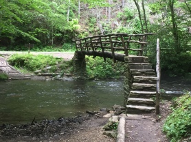
Cataloochee has proven to be one of my most favorite sections, first because of its remoteness. One does not go there by accident as any entrance involves several miles of gravel mountain roads, which are closed in the winter months. Secondly, the Park reintroduced elk to the area and they make their home in the valley. And thirdly, because of the diversity of hiking. The new plan called for two loops. The first included Caldwell Fork, Boogerman, a section of Rough Fork and the Big Fork Ridge trails. The forecast called for rain and it delivered. As I entered the valley, a shower opened up, giving me an excuse to drive through the valley and check it out. I met a couple backpackers on the road and offered them a dry ride but they were near their cars and  politely declined. The Caldwell Fork trail head is near the Cattaloochee campground with a small parking area at the footlog bridge over Cataloochee Creek. The rain abated at around 2:00 as I donned my pack and crossed over. As footlogs go, this is the best I have seen with stone steps and handrails on either side; a welcome and fitting entrance. It’s a short walk to the Boogerman trail, which loops off the Caldwell Fork Trail and back to it 3.9 miles later. The name comes from one of the early Cataloochee citizens, Robert Palmer, was called upon in primary school to recite what he wanted to be when he grew up. His reply was to be “the Boogerman” and apparently it stuck. The trail was named in his honor as he was one of the landowners of the area.
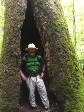
 The walk is well graded and carpeted with evergreens as one saunters moderately uphill. The laurel were blooming with some still in buds while others were already dropping their petals. A little sprinkle reminded me of the forecast but it lasted only minutes. About 2.25 miles there is a giant Tulip Poplar at the left of the trail. This is a granddaddy tree with its root feet reaching out from its 6 foot trunk. It is notable for its size but one notices a bit of a path around and behind this titan. I am so thankful that I decided to take a look because on the backside, the tree is hollowed out and large enough to stand tall inside. The trail continues in its moderate climb until about 2.8 miles when there is a steep climb and the the trail descends back toward Caldwell Fork Trail. At 3.3 miles there is a well-built stone wall notable because it used no mortar in its construction. A side trail leads off to the left at around 3.7 miles to a very small cemetery plot with two four small stones marking two graves, mostly like of two children. There are a few stream crossings to conclude the Boogerman trail as it returns to Caldwell Fork trail. I followed Caldwell Fork for a half mile and then turned right onto the Big Fork Ridge Trail, making the shape of this hike a bit of a figure 8 loop.

Less than a tenth of a mile in, the trail crosses Caldwell Fork, which on this day was swollen and rushing swiftly. Fortunately, there is a friendly footlog to keep one’s feet dry. The path climbs moderately a mile and a half to a small clearing and heads back down to Cataloochee road. As I neared the end of the trail, I noticed an buck elk in the woods. Although he had not grown his rack of antlers for the season, he was still an impressive beast and he took note of my presence. Less than a tenth of a mile later, a female elk was grazing just off the trail. Stopping to take her picture, I became aware of another presence to my left where I looked and saw the buck watching me through the trees, perhaps checking up on his mate as this stranger invaded their afternoon meal.
 The Big Fork trailhead is at the very end of Cataloochee Road, where the trailhead for Rough Fork Trail is also located. My destination is CS #40, which is a mile and a half down Rough Fork Trail. The trail is a gravel jeep track and descends ever so slightly as it follows it namesake, which you cross on a sturdy footlog a half mile in. At one mile, you arrive at the Woody Place, which is a farmhouse that is well preserved and open for exploration. The house was pretty luxurious by most standards as there are several fireplaces and closets in every room. The trail leaves the road at the Woody place and continues gently uphill to CS #40, which is my home for the night.
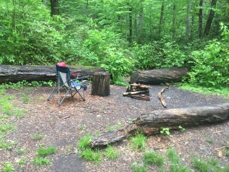
 Campsite #40 is amidst a rhododendron thicket, well off the trail with small clearings here and there. At the back of the site, where the main fire ring is, I found a couple folding camp chairs someone had left. I chose a couple sturdy trees to hang my hammock and set about my back-country domestic duties that included getting water and cooking supper. It was far too wet to consider building a fire and despite the lush greenery of the site, I found very little dead-and-down wood. But I did enjoy sitting in a chair while I prepared my freeze dried banquet of Thai chili noodles and a desert of dark chocolate.
After an unusually restful evening (I don’t normally sleep well the first night out…), I made my breakfast of oatmeal and coffee and took off by 7:20 am. The trail ascends steadily from CS #40 and will take me a mile and a half back to the end of Caldwell Fork Trail. At that point, I left Rough Fork Trail as it continued uphill to Polls Gap and I started the full length of Caldwell Fork.
 A treat arrives by 1.2 miles in, which is “Big Poplars”. A short side trail takes you to a huge Tulip Poplar tree which is one of the largest I have seen in the park. Just past Big Poplars is CS #41 located on Caldwell Fork, which is a nice site for tents. Crossing the creek on a footlog, the trail gently descends as it follows it namesake all the way back to the trail head. At 1.7 miles, you pass the intersection with Hemphill Bald Trail marked by a large pile of rocks. Hemphill Bald is a spectacular site, but it will have to wait for another time.
There are a number of stream crossings along Caldwell Fork, many of which are rock hoppers but these require as much care as any. One gets complacent by the seemingly simple hop from one rock to another. But just as the attention wavers, the foot lands on a slick rock and you find yourself getting up out of the mud with a bruise or two on the legs and hands. I was reminded of this reality about 3 miles in. McKee Branch Trail comes in at 3.1 miles. At 3.6 miles, I passed the south end of the Boogerman Trail and the next 2 miles proved to be wet… very wet. There are a few footlogs but a couple are in bad condition. This whole section is swampy with several muddy crossings and at 4.4 miles, there is a wet ford in knee deep running water. At 5 miles, the Caldwell Fork invites back into itself with another knee deep wet ford and yet another deeper one at 5.2 miles, where I had to remove my iPhone from my pocket to keep it dry. A third ford is at 5.2 and a fourth at 5.3 miles. With great relief, you get to cross Caldwell Fork on a footlog at 5.4 miles, which was fateful because a ford here would have been a bit treacherous. At 5.9 miles, I passed the head of the Boogerman Trail letting me know I am close to finishing this wet, muddy, sloppy trail. The last bit is level, pleasant and ends where I started at the nice footlog back at Cataloochee Road.
While I did not plan on it, I am glad I hiked Caldwell Fork Trail in the direction I did. Starting this hike with 4 wet fords in the first two miles would have made for miserably wet feet for the rest of the day. In future hikes, it should be noted the Boogerman Trail conveniently bypasses the wet section of the Caldwell Fork trail and may be worth the extra 2 miles of hiking to keep your feet dry. A philosophical dilemma for future discussion.
All in all, this was a nice one-night backpacking loop that leave time for exploring the valley or starting the next loop…
Strider Out!

