Category Archives: Philosopher’s Guide

Technology for the JMT

It is now 4 days from the time I board a plane for Reno, rent a car and drive to June Lake outside of Yosemite.  I am finalizing my gear and packing everything up for the trip.  The last unresolved decisions involve technology and I have brought that process to a close.  Here is the tech that will accompany my 211 mile trek on the John Muir Trail;

  • InReach Explorer
  • Garmin Etrex 30x
  • Apple iPhone 6
  • Ankar PowerCore 20100 Battery Charger
  • Assorted cables and adapters
  • Total Weight:  2.1 lb


Tech for JMT

InReach Explorer

The InReach Explorer has two key functions; satellite texting and SOS emergency communication.  The texting, although crude in the user interface, will be the only way I have to communicate in the remoteness of the JMT.  All my research indicates the trail is generally beyond the reach of cell tower signals.  The InReach will hold a charge for about 4 – 5 days of hiking. It will track my progress and post to a website where friends and family can follow.  Weight: 6.8 oz

Garmin Etrex 30x

This is a brand new edition to my gear set.  I wanted GPS capability that was not available in the InReach but my Garmin fenix 3 watch was not going to make the cut, primarily because it only holds a charge for 2 days of full hiking and needs to be recharged.  I chose the Garmin Etrex 30x for its basic GPS functionality and the fact it runs on AA batteries.  The specs indicate it will run for 16 hours so I’ll carry extra batteries.  My testing has proven the device to be reliable and easy to use.  Plus it will upload results to my Garmin Connect website, which is what I have been using now for years.  Weight:  5.7 oz

Apple iPhone 6

The iPhone will be my camera, saving  about 4 lbs of camera gear.  The iPhone took great pictures in the Grand Canyon so it should be fine.  I found a telephoto lens that is small and weighs nearly nothing.  I have maximized storage space by getting rid of most apps (including email), pictures and media leaving about 54 GB for photos and video clips.  I don’t believe the empty memory space save any weight.  I could not find how much a GB weighs anyway.  In airplane mode, the battery should last 4 or 5 days. Weight:  7.8 oz (w/ lens)

Ankar PowerCore 20100

The iPhone and the InReach Explorer will need to be charged at least once before I get to Muir Trail Ranch and probably twice between there and Mt. Whitney.  I researched a number of websites and blogs, considering solar chargers and high density power chargers.  One has to learn how these devices are rated and fortunately, the hiker community has developed a bit of a standard of how many times you can charge your smartphone.  The chargers are specified by the number of milliAmp hours, but one thing to note, the airlines have a restriction on lithium batteries measured in Watt hours, which is the total volts multiplied by the Amp hours.  The limit is 100 Watt hours.

I opted not to use a solar charging system.  The ones I researched indicated you needed to charge the battery a full day to get 1 smartphone charge.  With two devices, I did not want to run the risk that they both ran down on the same day.  Plus, many of the reviews indicated that weight was a bit of an issue when you count the flexible solar panel and the battery in the system.

That leaves the lithium battery chargers.  I found these are typically rated in milliAmp hours (mAh).  A 7,800 mAh will charge a smart phone up to 3 times and weighs around 6.5 oz.    More is better right?  But bigger chargers come with more weight.

My choice ended up being the Ankar 20100, which is a 20100 mAh battery charger weighing in at 12.7 oz.  The literature boasts 7 charges of a standard smartphone.  It has two USB ports making it possible to charge two devices at a time.  Running the math, it registers a 72.6 Wh capacity, which should not be a problem for the FAA.

Assorted Cables

A USB for the phone and the InReach, plus a 10W power adapter weigh in at 3.5 oz.

HikerHead 2

Strider Out!

Why Did You Come Here?

IMG_0366

Sunset On Mt. LeConte

He was pacing back and forth on a small section of the North Kaibab Trail, 200 yards or so north of Phantom Ranch at the bottom of the Grand Canyon.  As I drew nearer, he was talking out loud, gesturing occasionally to no one around him.  The conversation concluded and as I passed him, he held up the smartphone and hit the “end call” button.  He turned his attention to me saying, “Can you believe it?  This is the only spot in the canyon where you can get a signal.”

As with any beautiful vista, one often shares the experience with others in quiet reverence as the moment is contemplated by each person’s reason for being there.  Such is the case at Cliff Tops on Mt LeConte at sunset.  There seems to be a profound respect shared by all who find themselves in the space and time of that moment.  It is a reward for the effort of hiking several miles and a few thousand feet in elevation.  However, there seemed to be a difference of opinion between two acquaintances in that the the one had no business saying what she said about the other; as the conversation was inadvertently shared with those around her during the moment the sky was on fire.  Apparently, there is a good signal up on Mt. LeConte.

“Why did you come here?”

The only electronics I took on my AT thru hike in 1984 was a flashlight, a digital watch and a small 35 mm camera, which had to be supplied with film. I replaced the batteries in the flashlight twice.  Navigation was accomplished by maps, a data book and the Philosopher’s Guide – all paper.  And the trip was documented in a small spiral bound notebook with a ball point pen.  The social network of the day was trail shelter registers, which were notebooks left by hikers providing news about trail conditions, AYCE restaurants in the next town, and who was hooking up with with whom.

The  presence of technology in the backcountry has changed the experience across the spectrum and like any powerful capability, one must come to terms with when to use it and when not to. Despite the tone projected thus far, please know that I am not a Luddite. I embrace technology, researching and carefully choosing which devices offer value to me and which require more support than the benefits they return.   The nature of this blog necessitates GPS technology to capture mileage, elevation and location.  My growing love affair with photography has opened up a completely new realm of technology possibilities.

My latest backpacking adventure underscored just how dependent I have become on my gadgetry.  Having  run out of battery charge on my GPS watch AND my smartphone, the last leg of my hike was not documented anywhere but in my mind.  No pictures, no voice recorder, no data.  I hiked the complete 7 mile length of the Pretty Hollow Gap trail in about two hours.  The next day, when I attempted to recount the section for posterity, I found I had little or no memory of the specifics of that hike.  For a blog that relies on information and data, this is bad.  The GPS, camera, and my voice reorder do in fact, help me remember details about each hike, solidifying the memory of them in my mind.  I remember where the water is in most campsites and I remember where all the big trees are.  I remember how many wet fords there are on each trail.  This is all good.

But I also came to realize that the hike down Pretty Hollow Gap put me in a state of contemplative flow, an experience which I have come to long for in the wilderness.  Without the constant awareness of checking the watch and recording where the switchbacks and stream crossings are, I was able to forget about time.  I remember being aware of the morning, the bird songs, the coolness of the air.  I don’t remember how steep the trail was and I don’t remember any stream crossings, although there has to be some.  There was regret in not having the information to document my hike, but upon reflection, what seemed to matter more was the memory of the contentment of that morning’s experience.  I reminded myself of the question –

“Why did you come here?”

HikerHead 2

Strider Out!


My JMT Gear List

fullsizeoutput_52aWhen it’s raining outside and you are too wimpy to go backpacking in it, you go through your gear, weighing everything in preparation for the obligatory gear checklist.  And of course, the picture of your possessions in the House on Your Back.  On the gear spectrum, I tend to fall near the ultralight folks but I am willing to make compromises for comfort and convenience and I readily admit this list is somewhat flexible.  I own no Cuban fiber.  But just for kicks, I did cut the handle off my tooth brush and I have been known to trim the borders off my maps.

The Big Three – 6.3 lb.

I am very pleased with how the big three (pack, tent, sleeping bag) ended up.  My ULA Catalyst is roomy for the bear can but I took out the plastic back support saving a pound.  I made the investment in a Western Mountaineering down bag and it was a good one.  I’m not yet convinced quilts have that much of an advantage, at least not enough to invest in one to save about 6 oz.  The one compromise was the tent over a tarp.  Ease of setup and built in bug protection carried the day.  The REI Quarter Dome one came in at only 2 lb. 2 oz. amking it the secound heaviest piece of gear.  I am still debating over my sleeping pad.  The Ridgerest is light but my old bones sure appreciate a self-inflatable.  That would add about 6 oz.

The Kitchen – 3.8 lb.

Here is where I will find out if anyone reads this stuff.  I DON’T GET THE ALCOHOL STOVES!!!  Check my previous article where I did a performance test between my super light and reliable MSR Pocket Rocket and my homemade alcohol stove.  My conclusion was whatever few oz. you spend on a stove/canister more than compensates for the amount of time… and fuel… it takes to heat water with alcohol.  The bear can is the obscene weight hog here at 2 lb 11 oz.  The rest of the kitchen is 1.1 lb.

The Closet – 3.9 lb.

I guess the biggest question here is whether to take the set of long johns.  They weigh almost a pound.  I like sleeping in them, even in the summer because they keep my bag clean.  I could save a half pound by using just the tee shirt and leaving the top.  The rain gear serves as wind protection.  The pants may get left home though since I tend to wear long pants hiking.  I don’t really need long johns AND rain pants for warmth.

Misc. – 1.5 lb.

The biggest weight here is my first aid kit at just over a pound.  It contains first aid stuff, personal grooming, sunscreen, Vitamin I  (ibuprofen), fire starter, duct tape etc.  I could shave an ounce or three here but I’m pretty good.

Camera Gear – 3.4 lb

This is my biggest debate over weight.  I love my Sony Alpha 6300 mirrorless camera.  It takes most of the pictures you see in this blog.  The iPhone does a great job and served me well in the Grand Canyon two years ago.  Plus they now make some pretty cool lenses for it that are reasonably priced.  My total base pack weight is 20 lb. so 3.4 lb. is a significant portion – almost 20%.  I really don’t have to decide until I hit the trailhead, which is probably when I’ll make it.

Plus, leaving the Sony at home would challenge me to shed one more pound to get to 15 lb base pack weight, which, with a bear can, would impress most any thru hiker on the PCT.

TOTAL BASE PACK WEIGHT:  19.99 lbs

Gear List

That is all…

HikerHead 2

Strider Out…


The Bear Can

Bear CanisterThere are a number of things that make hiking out west different from hiking in the Smokies.  Elevation is one thing.  From what I can tell, I’ll be spending most of my time above 10,000 feet.  Mt. LeConte is 6594′.  Clingmans Dome is 6644′.  The tallest mountain in the east, Mitchell, is 6683′.

At those elevations, one spends a lot of time in the Sierras above tree line, which occurs around 9,500′.  No trees, no hammocks or bear bags.  And no bear cables like we are accustomed to in the Smokies.  But there ARE bears.

To that end, the Park Service and the National Forest Service require bear canisters for storage of all smellables like food, toothpaste, sunscreen, deodorant (deodorant, really???  People take deodorant???). No one ever talks about whether body odor smells like food to bears or mountain lions.

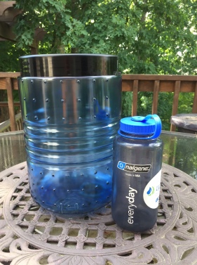
Bear canisters are available for rent, I have read, but I decided to go ahead and get my own.  I chose the Bear Vault BV 500.  I’m not sure what the “500” means.  It holds 700 cu.in. or 11.5 liters and it’s 12.7 in high and 8.7 inches in diameter.  And… it weighs 2lb 11 oz. REI price: $80.

The upsides are it is guaranteed bear proof, although there are pictures in blogs where they have failed, you don’t have to hang a bear bag, and it provides a great seat upon which to rest while cooking dinner.  At the end of the day, you just set the can 200 feet away from the tent and hope no one plays overnight soccer with it.

The downsides – big and heavy and expensive.  The BV 500 is among the cheaper options.  They can go as high as $200 and weigh over 3.5 lb.  All this light weighting I am trying to employ goes away when you add nearly three pounds of food container, making it the heaviest single item in my pack.  And unlike a good water proof food bag, it does not get smaller when you eat the food.

That’s I have to say about that…

HikerHead 2


Shalom –

Strider out!

The 900 Miler Data Book is in the works!

This is my 2nd 900 miler and this blog was created to document the experience and to share hiking philosophy.  The site continues to evolve and has become many things as I experiment with different ways to capture this odyssey.  One of these is an online guidebook.  Another is a thorough review and index of the campsites.

AT Trail Data BookToday, I am introducing another branch of this project which is the 900 Miler Data Book.  The idea came from the Appalachian Trail Data Book, which is updated and published every year by the Appalachian Trail Conservancy.  When I was a through hiker, I carried three pieces of navigation information; the section map, the Philosophers Guide to Hiking the Appalachian Trail, and the Data Book.  The Data Book is a summary of each section of trail, along with major landmarks and milestones in a small, pocket-sized book.  On long trail sections, it was indispensable because it was often the only way to gauge progress  based on mileage.

As I was “mid-map” on the last 900 Miler, I found myself wishing I had a better idea of what lied along each trail.  Just how many creek crossing are on Eagle Creek?  Where am I likely to get my feet wet?  What is the elevation gain (loss) in either direction?  What interesting landmarks should I be on the lookout for?  Where does that side trail go?

“Hiking Trails of the Smokies” (The Brown Book) is a great guidebook, but it is heavy and the narrative style is not very concise for this purpose.  The National Geographic Map is also a handy resource that I carry at all times but it lacks the details I am looking for.  Ken Wise’s book, “Hiking Trails of the Great Smoky Mountains” is excellent, especially since I can get it electronically and download it on my smart phone.  Ken has done a great job combining a trail summary with a detailed narrative of each trail.  Again, I am looking for an abbreviated trail summary.

Low Gap II Data BookSo on this 900 Miler, I have endeavored to create a Data Book in the style of the AT Trail Data Book.  You have seen a section of the specific trail included on my more recent accounts.  Having completed nearly 60 trails so far, I decided to create a PDF of my spreadsheet and make it available.  I’ll add the details of each trail as I hike them.  By the end, I hope to be able to publish the result in a small pocket-sized version.

Here is the link to the PDF:   900 Miler Data Book Rev.1

Check it out and let me know what you think.

HikerHead 2  Strider out….

Solo Hiking and the Art of Hitchhiking

Hitchiker Pic900 Milers generally prefer loops.  It makes traveling in one vehicle simple.  But some hikes simply do not lend themselves to convenient loops.  Key swaps are a good strategy for avoiding the double mileage of Yo-Yo’s and lets’ face it, a few trails are long and do not fit well into loops.  Old Settlers Trail, at nearly 16 miles, is a case in point as it traverses between Cosby and Greenbriar.  Even shorter saunters like Roundtop Trail and Cove Mountain Trail come with logistical challenges for the solo hiker.  In remote areas like Parson Branch Road, sometimes you just have to hoof a road walk to get it done (like when I planned my road walk against the one-way traffic like an idiot…).  I find two options worth consideration.

First, hitchhiking.  One should always consider their own comfort and personal safety in choosing this option but even then, there are ways to hedge your bets and leverage in favor of safety.  In my case, I am about 80% successful hitching rides along the main thoroughfares like Little River Road, Laurel Creek Road and Newfound Gap Road.  It’s usually the fishermen who are most sympathetic.  Maybe it’s because they drive pickups and they have been standing knee deep in cold water all morning.  Despite the relative high numbers, I have never been offered a ride on a motorcycle.  No judgement, just sayin’.

Here are a few tips I find helpful:

  • Position yourself near pull-overs and overlooks.  Slower traffic increases your odds and it also gives would-be angels a place to pull over for you.  Your chances of getting a ride in curvy stretches with no pull outs are about as good as finding a parking spot at Ramsey Cascade Trailhead after10:00 on a Saturday.
  • Be visible.  It sometimes takes Karma a few seconds to work on some drivers.  Find a good straight section of road.
  • Smile and wave at those who pass you by.  You’re an ambassador for your kind and while they may not stop for you, they may the next time if they find hikers to be friendly.
  • Be patient.  It often takes about 20 minutes for a connection to make.
  • You may have to ride in the back of a pickup.  Make sure you have gloves in February!
  • It behooves oneself to present in a manner as to not appear like one who refers to oneself as, “one”.  Look friendly and safe.  Smile.  No one stops for smug 900 Milers with a strong air of entitlement or for that matter, someone who looks like they have a strong air.  Try to look like you smell good!  Save the condescension for your Facebook post.

Best Advice: If you meet up with other hikers, especially near the trailhead, mention you need a ride.  Birds of a feather.  This has worked twice for me in the last month.  I completed a backpacking trip at the Gregory Ridge Trailhead at the turnaround on Forge Creek Road.  It’s about 2.5 miles back to Cades Cove but that weekend, there were plenty of hikers on the trail.  I passed a couple near the trailhead, exchanged some trail intel in a polite and gentile manor.  They were happy to give me a lift back to the Cove.  The second instance came with a hiking partner who finished up on a side trail while I negotiated the arduous climb and subsequent descent of Smokemont Loop trail.  The car was several miles up at the trailhead at Kephart Prong Trail.  She met up with a hiking group, made quick friends and not only scored a ride but a cold soda to boot.  When I got to Smokemont, the car was there at the end of the trail.  Uber of the Smokies!

Recycle that ‘cycle. Another option I piloted successfully this past Memorial Day.  I needed Chestnut Top Trail and the prospects for hitching a ride from the trailhead at Schoolhouse Gap Trail back to the “Y” were pretty good given the trail’s popularity with day hikers and tourists.  But I had been itching to try a bicycle solution.  So I got a heavy cable and a good lock and stashed my mountain bike a little ways up the bank at the parking area.  Then I drove back to the “Y”, lashed my bike helmet to my daypack and had a glorious morning of hiking.  When I arrived at the trailhead, the bike was there safely cabled to a tree.  In less than 5 minutes, I was headed down Laurel Creek Road and 20 minutes later, i was on the way to the Burgermaster in Townsend.  It really helps to plan for a downhill ride.  Climbing up to Laurel Falls is a killer, even for seasoned lycra-clad cyclists on expensive road bikes.

And one more thing…

Bank your Mojo.  Karma counts! I give a ride to a fellow hiker every chance I get.  Sometimes, even when they are not hitchhiking.  Chances are, if you see someone hoofing it on the side of the road with a daypack, they are headed for their car.  If you help them out, he or she may see you the next time, or the next hiker.  Even the fishermen appreciate being asked if they need a lift.  Just remember not to blame Karma when the ride never comes.  Mojo doesn’t work that way.

HikerHead 2  Strider Out!


Agony of DeFeet

The gear question I tend to get most often is, “what kind of hiking  shoes should I get?”.  “I don’t know.  I’ve never used your feet,” is typical as my reply.  The feet are the most vital set of hiking equipment we have determining, perhaps quicker than anything else, whether a hike is ultimately remembered fondly.  It is also a defining factor for novices as to whether they stay with hiking.  Cheryl Strayed went into excruciating detail about her feet in her book Wild, ultimately leading to losing her boots over the side of a cliff.  As far as I remember, her feet were not in them at the time.

My feet are highly personal to me.  I am the only one that ever uses them.  I never loan them out.  And like most earth traversing bipeds, we have plenty of time to think while hiking. So I developed my Philosophy of Feet.  There are plenty of great websites that give all the basic advice on shoe selection.  This post is about coming to terms with our feet and and perhaps confronting a myth or two that leads to expensive purchases, and of course, extra weight.

The Myth of Dry Feet

Abrams Creek at Hannah Mountain Trail

Abrams Creek at Hannah Mountain Trail

The Great Smoky Mountain National Park is a rain forrest.  Average annual rainfall in the park ranges from 55 inches in the lower sections to more than 85 inches atop the ridges.  To our great fortune, that water moves down the 2,900 miles of rivers and streams, over the spectacular falls and cascades that present the symphonies of water music and the lullabies that sing us to sleep.  Some trails are known for their prolific number of stream crossings; Eagle Creek (17), Beard Cane (16), Lakeshore (15), Bone Valley (5 crossings in 1.8 miles) and others.  Abrams Creek must be forded knee deep twice, at Hannah Mountain Trail and lately near the Trailhead on Rabbit Creek Trail with the bridge washed out.  Rock hopping gets you over many of the crossings but ultimately, you will either slip or find there is not a suitable dry crossing.  Rock hopping in winter is downright treacherous as invisible ice forms on rocks inviting your feet to land, only to land your bottom in the creek.

The Myth of the Waterproof Boot

Waterproof boots are better at holding water IN than they are keeping water OUT.  And unless you never hike in the rain or always wear fisherman’s waiters, water will get into your boots.

Born To Run

Born To RunChristopher McDougall’s book Born To Run was a deep dive in how humans were built for covering long distances on foot and how modern technology has actually interfered with our natural ability to do so.  He lived with the Tarahumara Indians of Mexico to learn how they can run hundreds of miles day after day wearing no more than thin leather sandals.  His hypothesis is that modern running shoe technology has provided too much cushioning and it impedes the natural movement of the foot and running gait leading to injuries.  He cites research that despite high tech shoes costing north of $150 per pair, foot and leg injuries have gone up over the years.  This has sparked a strange movement of barefoot runners and minimalist running shoes, which is a topic for another time.  But the bottom line is that over-cushioned and stiff soles, interfere with the way our feet flex and adjust to the terrain in which we walk.  Notionally, we are better off with fewer restrictions in binding our feet in shoes.

A Pound On Your Feet Adds 5 Pounds To Your Back

This axiom has been around for decades.  There’s a great article by 

Blistering Heat

The source of blisters is almost always bad fitting shoes, meaning shoes that are too small and too inflexible.  Blisters are caused by friction.  While excess movement can be a contributing factor, it’s the conditions of that movement that actually lead to the burns.  Rigid inflexible shoe soles cause the feet to move inside the shoe.  Built up moisture softens the skin and worsens the effect of excess movement.  Feet also like to move in the shoe.  Shoes that are too small restrict the natural movement of the feet (such as the toe region) and force the movement toward the pads of the feet.  Feet swell when hiking.   Tight fitting shoes displace this natural movement to other parts of the feet that are more prone to blisters.

The Water’s Fine…

West ProngIt was perhaps in the Pretty Hollow Gap area, after several unsuccessful attempts at rock hopping that an epiphany struck.  I have spent a lot of money and tried a lot of tricks (gaiters, wrapping my feet in plastic trash bags, no really) and hopped (slipped on) a lot of rocks and carried heavy sandals and expended a lot of stress and emotion… all in the quest of dry feet.  On this day, it rained and when it rains, you give up to being wet.  In that moment, I unconsciously quit worrying about getting my feet wet.  It simply didn’t matter anymore.  Then my mind played a strange trick on me.  It brought this thought to my consciousness.  When you’re not worried about getting your feet wet, rock hopping is no longer an imperative.  Then you realize that wet feet, once they’re wet, are not so bad.  It became one of those existential questions; “Why am I here?”, “Where did I come from?”, “Why am I afraid to get my feet wet?”.  Water is the stuff of life.  It’s one of those things that made life possible on this third rock from the Sun.  I was freed that day of the fear of wet feet.

And So…

When you embrace the inevitable fact that your feet will get wet when you hike 900 miles in the Smokies, it opens up new possibilities to how your dogs are shod.  You no longer require waterproofness.  In fact, you will seek a shoe that leaks like a sieve because you want the water to have an easy exit.  It’s not about the presence of moisture but the amount and where it goes.  This is a thing that will confuse the sales person at the outfitter as they try to convince you to buy expensive GoreTex; “No, please show me your lightest, most leaky shoe first.”  Chota makes shoes for canoeists who paddle the Boundary Waters of Minnesota.  The proper way to ingress a canoe is to walk into the water with the boat afloat and step into it.  Wet feet are a given.  Chota actually puts little vents on the insoles of their shoes so the water can flow right out.  I have been known to punch a couple small holes in the insole of my hiking shoes.  When I ford a creek, my feet are pretty dry within a half mile or so of hiking because the water works it’s way out of the shoe pretty quickly.  Slightly damp, yes.  Soaked no.

Sock It To Me

The old school traditional wisdom on socks was to wear thick wool socks with thin polypropylene or silk sock liners.  This was in the era of heavy full grain leather mountaineering boots, which were about the only option available to hikers back in the day.  The wool socks were padded and insulating and the liners were for wicking moisture away from the skin.  Since the liners couldn’t absorb and keep moisture, the feet remained slightly damp rather than completely soaked.  Plus, the liners served as a second skin to guard against friction.  Some lightweight guru along the way asked a simple question.  “If my shoes drain well, why do I need the thick socks?”  Ray Jardine advocates cheap men’s dress socks which you can buy for 3/ $10 at your favorite discount retailer.

The Cold Truth
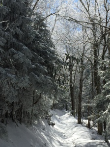
Snow on Maddron Bald Trail

Snow on Maddron Bald Trail

It’s been my experience that hiking keeps your feet warm. Even in the winter through snow. Most 900 Milers avail themselves of the off-season, especially for the more popular trails.  I hiked Maddron Bald the end of February in 8 inches of snow.  If it’s winter and you hike above 4,500 ft., you’ll hit snow.  Yes, my feet get wet and cool.  But I never have a problem with severe cold.  When my hiking is suspended for the day, I make sure to have dry warm socks and in the pack.

Soul of the Sole

Salomon XSCREAMMy ideal shoe is the lightest, leakiest, reasonably flexible, least padded, cheapest shoes I can find.  I pair them with thin ankle high merino wool socks.  I have about 600 miles on a pair of Salomon XSCREAM trail runners.  They weigh together 1 lb. 6 oz.  They only have a few miles left and I will be sad to retire them.  As far as I can tell, Salomon discontinued the model and replaced them with the X Mission 3.  One of the gripes I have with gear providers is that in order to project cutting edge design and a sense of what’s new, they tend to retire good products for no other reason than they are so last year.

My feet have never been happier since I went lightweight and free flowing.  I rarely blister and I don’t have aches and soreness from moving against rigid hard soles.  My preference is still to rock hop creeks if reasonable but a good soaking is no longer the end of my happiness.

Of course, I could be wrong…

HikerHead 2  Shalom.  Strider out…

In Search of the Optimum “Big Three” and The Impact of the Sales Pitch

A Tale of Two Hikers

The Big Three copyAny article on lightweight backpacking mentions the big three; Tent, Sleeping Bag and Pack.  Two recent experiences have led me to believe the attainment of lightweight enlightenment with regard to the Big Three is more elusive than previously credited.  In the first case, a friend is in the first couple weeks of her Mountain-to-Sea Trail thru hike across North Carolina and she is experiencing the typical break-in period most thru hikers face:  shaking down equipment, initial confrontation with less than desirable physical condition and the realization this is going to be hard.  And like most freshman thru hikers, there is the inevitable effort to lose pack weight.  I had provided some pre-hike coaching and helped her shed a few pounds but when we had a telephone catchup, she was still hauling over 30 pounds.  So we went through everything, item by item, starting with the Big Three.  She reported to me that her sleeping bag, pack, tent and sleeping pad still weighed about 17 lb. which couldn’t be true because the tent and bag were only about 5.5 lb. together.  I know because I loaned them to her.  The pad was another pound and finally we got to the root of the matter.  Her pack weighed nearly 7 lb. empty.  She bought a good pack from a reputable outfitter.  No blame here but a 7 lb. pack for someone less than 5’6″ was a bad fit.

Now to the second part of the story.  Yesterday, upon returning from a day hike with a friend on West Prong Trail, I engaged in one my my favorite post hike celebrations in Maryville.  That being a stop at Little River Trading Company.  I wanted to share what wisdom I could on backpack choices.  A helpful sales guy was right there at the backpacks and was quick to engage us.  I stood back and listened to his approach to see where he would lead my friend.  He asked to typical questions like, “what kind of hiking are you going to be doing?”  At no time did the question of weight come up.  My friend’s attention was directed to a popular brand with plenty of room and would certainly meet his technical needs.  But pack weight was never discussed, even when I suggested the lighter weight brand I prefer.

Sales people are no doubt helpful but it is my contention they rarely steer the novice toward the lightweight options unless pressed to do so directly.  With packs, the thing is size and suspension technology.  With sleeping bags, it’s temperature rating and price and with tents, well I’m not sure because I’ve never bought one from a store.  And this is why my Mountain-to-Sea Thru-hiker friend is carrying over 25 lb. in base pack weight. So here are two basic rules when looking for one or more of the Big Three, or any other piece of gear.

Basic Target Weight for the Big Three

The maximum target weight for the Big Three combined is no more than 9 lb. total weight.  Breaking that down, target 3 lb. for a tent, 2.5 lb. for a summer weight sleeping bag and no more than 3 lb. for a pack.  It’s not difficult to do less weight but you start to run against cost, especially with sleeping bags.  Tent’s and packs weighing 3 lb. or less each are no less durable or more expensive than any others.  Beware the popular brands that offer a lot of features and technology.  That translates to cost and weight.  My North Face summer down bag weighs about 2.5 lb. and my Eureka one-man tent weighs barely 3 lb.  Neither came with a hefty price tag and both can be found on sale for $150 each or less.  My ULA Circuit holds 4,200 cubic inches and weighs 2.5 lbs.  It sells for $235 which is comparable to other major brands.  Total for theBig Three in this example: 8 lb.

Helpful Sales People: How to Help Them Help You

Outfitters offer a great service and they desire to get you quality gear but like any other sales person, if you go in without some prep work, they will make recommendations based on their priorities, which is to sell you the best pack in their opinion.  They may not put pack weight at the top of the list of most desirable features so you will have to.  Pack weight should be number one after good fit.  Size should be secondary.  3,500 cubic inches is plenty for week long trips as it is quite enough for through hikers.  Sales people may direct you to bigger packs so you will always have enough room for whatever but size adds weight.  Most popular brands have lightweight models at reasonable cost.  You just have to ask.

Use the same strategy for sleeping bags and tents.  If they can’t offer you a reasonably priced product under 3 lb., move on to another store.  Or find a good friend with extra gear to loan you…

Erik The Black’s Backpacking Blog has a great article with further wisdom on choosing the Big Three

HikerHead 2  Shalom.  Strider out…

Trail Names and 900 Milers

Holy Family Hiker Hostel in Pearisburg, Va.

Holy Family Hiker Hostel in Pearisburg, Va.

It was the at the Holy Family Hiker Hostel in Pearisburg Va. when it happened. It was early June and I had just arrived to find a gentleman checking out the hiker register.

“Hi, I’m Shawn.”

“I’m Warren.  When did you start?”

“May 6th”

“Wow, you’re a runner aren’t you?”

The Runner… THAT’S IT!  Some 600 miles into my AT Thru Hike and I had a trail name.  And it came from one of the folklore heroes of the AT.  Warren Doyle has hiked the AT 16 times and at one time, held the speed record.  I hadn’t chosen a trail name at that point but I was aware of the tradition.  Some chose their trail names before they begin their hikes.  Some believe it should be bestowed upon you while on the trail.  I guess in my case it was more of the latter.

Adopting a trail name is part of the long distance hiker community.  Most Thru Hikers on the AT and PCT alike take on some form of alter ego.  The name may come from a specific event or it may refer to some aspect of personality.  Mouse Slayer carried mousetraps to ward off the beasts in trail shelters. The Umbrella Lady carried, well you know.  There was The Snail, The Old Soldier, Hog, Moses, TomNBev and The Exodus and many many others.  From Pearisburg on, the thru hikers I met become known more by their trail names than their given names.  It always made introductions interesting.  A good trail name should come with a good story.  Being a fan of the Hitchhiker’s Guide, I even gave my pack a handle; The Runnership Jansport America.

The 900 Miler community hasn’t seemed to embrace the tradition, perhaps because most of us are not Thru Hikers.  Furthermore, there is no system of communication like the shelter registers in which to document our experiences through our chosen identities.  We tend not to congregate at campsites and hiker hostels.   Becoming a 900 Miler does not involve a full-time commitment like being a Thru Hiker.  We don’t leave behind our civilian lives for the duration of the trek, which diminishes the need for an alter ego.

And yet, there were 30 who became 900 Milers in 2015. There are more than 475 900 Milers registered with the 900 Miler Club.  Maybe there is a critical mass necessary to ignite the use of trail names in the 900 Miler community.  If you track the list of AT Thru Hikers over the past several decades, it wasn’t until the 1970’s that trail names started to show up at all. The critical mass seemed be reached in the 1990’s and by 2000, it was unusual for a Thru-Hiker not to have one.

This is not a call for the 900 Milers of the world to adopt trail names.  That said, it’s not a bad idea and I think I’m going to go there.  Perhaps the 900 Miler Club should include a column for trail names like the ATC and the PCTA and see what happens.  To this end, I have narrowed down to three possibilities:

Saunter – John Muir rejected the notion that he was a hiker.  Borrowing an idea from H.D. Thoreau, he explained that saunterers were spiritual pilgrims who traveled by foot and he preferred the term.

Wayfarer – is a person who travels rather leisurely by foot.  Plus, the name reflects my chosen form of protective eyewear.

Strider – reflects one who travels by foot but more swiftly.  It is the nickname used by Aragon in the Lord of the Rings while he was a Ranger of the North.  Mysterious! 

Let’s see which one takes…

HikerHead 2


The 10 Essentials

Every year, there is a least one story that makes the local press about an individual who got lost in the Smokies for a day or two until the park service found them, cold and hungry.  Recently, there was a family of four who spent a miserable cold night up on Mt. Le Conte.  It seems despite the fact that the trails are well marked and the availability of good maps, people still manage to venture out in street shoes with a small water bottle and little else.

In full disclosure, I must admit that I have been lost once.  The map I had was several years old and the Lakeshore Trail had more recently been rerouted.  The campsite we were bound for did not materialize within the expected timeframe and the topography on the map indicated a much different terrain than what we were currently hiking.  We were supposed to be on the Lakeshore Trail and the last sign we passed confirmed that in fact we were… on the Lakeshore Trail.  We were just on the wrong Lakeshore Trail according to my obsolete map.  Fortunately, we encountered a fellow wayfarer who was in possession of a newer and more accurate map.  Given that we were backpacking, we were never really at risk and we were soon properly oriented and back on track.  The point is, everyone gets lost, sooner or later.

Much of my hiking is done solo for personal and spiritual reasons and 900 milers hike trails that are in the far reaches of the park where the maintenance crews rarely visit.  The possibility for an obscure trail without a sign is there.  Even with a hiking companion, water bottles are lost and food is forgotten.  And in the case of injury, one of the party may have to get help while the other party hunkers down to wait for rescue.  With proper planning, the folks at home should know where you are going and when you plan to return.  So if you are somehow lost or injured, you need to be prepared to survive a night in the backcountry.

The concept of the Ten Essentials was originally developed and published in the book, Mountaineering, Freedom of the Hills in 1974.  The idea was to develop a fundamental list of gear one should always have in the outdoors to facilitate a night’s survival in the wilderness in the case of injury or disorientation.  Bearing in mind, the list was developed well before the advent of the smart phone, it is understandable that the device failed to make the list:

The Classic Ten essentials

  1. Map
  2. Compass
  3. Sunglasses and sunscreen
  4. Extra clothing
  5. Headlamp/flashlight
  6. First-aid supplies
  7. Firestarter
  8. Matches
  9. Knife
  10. Extra food

My first encounter of the Ten Essentials was through the Boy Scouts.  Every checklist of camping gear starts with the Ten Essentials and their list is quite similar:

The Boy Scout Ten Essentials

  1. Pocket knife
  2. First aid kit
  3. Extra Clothing
  4. Rain gear
  5. Flashlight
  6. Food
  7. Water
  8. Matches
  9. Sun protection
  10. Map and compass

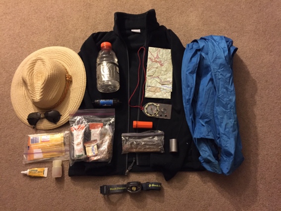
New developments in gear and the movement toward lightweight have refined the concept into more of a systems approach and the list is now a set of categories rather than 10 specific pieces of equipment.  Also, there are seasonal and geographical considerations.  Here are the updated 10 Essential Systems along with some personal commentary:

  1. Navigation – To date, the National Geographic map of the Smokies has proven to be a stellar method.  I also carry a compass although it is rarely consulted.  My watch has an altimeter feature and a compass so with the map, I can usually locate my position within a quarter mile or so.  I have yet to be enticed to acquire GPS systems.  Cell phones can work but they cannot maintain a battery charge for very long.
  2. Sun Protection – Hat and sunglasses.  If I anticipate spending an afternoon on a bald, I may carry sunscreen as well.
  3. Insulation – At the very least, even in summer, I take a fleece and my rain jacket.  In the winter, I add layers, gloves, a warm hat (beanie, toboggan, ski cap, skull cap, or touk, eh?), rain pants and a down jacket.
  4. Illumination – Headlamp, always.
  5. First Aid Supplies – The outfitters have small lightweight individual first aid kits with all the essentials.  I typically add Vitamin I (ibuprofen), a small tube of Neosporin, and a chaffing cream of some sort.
  6. Fire – Waterproof matches in a plastic waterproof case. I also cary a lighter but the matches are lightweight and a good failsafe.  i also carry a couple sticks of fire-starter material.  It rains all year in the Smokies.  Scoutcraft aside, it helps to have a quick way to start a fire.
  7. Repair Kit and Tools – A lightweight pocket knife and a small bit of duct tape.
  8. Nutrition – I always throw in extra granola bars and plenty of GORP and nuts.
  9. Hydration – a water bottle and a Sawyer filter.
  10. Emergency Shelter – Interestingly enough, this list did not specifically call out rain gear, which is a serious oversight.  Although I included rain gear in the insulation discussion, I always carry a rain jacket.  In cooler situations, I’ll throw in the rain pants.  The advice here also calls for a light tarp, something which I rarely have carried on day hikes but I do have silnylon rain poncho that could serve as a tarp.
  11. Knowledge – There is always the “plus one”.  In this case it’s knowledge.  a compass won’t do you any good if you don’t know how to use it.  Starting a fire in a fireplace with dry newspaper and a lighter is easy at home, but in the rain with wet wood is a whole other matter.  Setting up a tarp in the wind requires some skill. Proper planning identifies routes and return times.

All of these items stay in my day pack or in close proximity.  The list helps to make sure the down jacket makes it in the pack.  There are most certainly other items you may consider essential so feel free to modify the list to include those.  And lightweight considerations need not be sacrificed.  My day pack rarely weighs more than 7 lb., even with water and winter gear.

Shawn's 10 Essentials

Shawn’s 10 Essentials