Tag Archives: Mt. LeConte

Why Did You Come Here?

IMG_0366

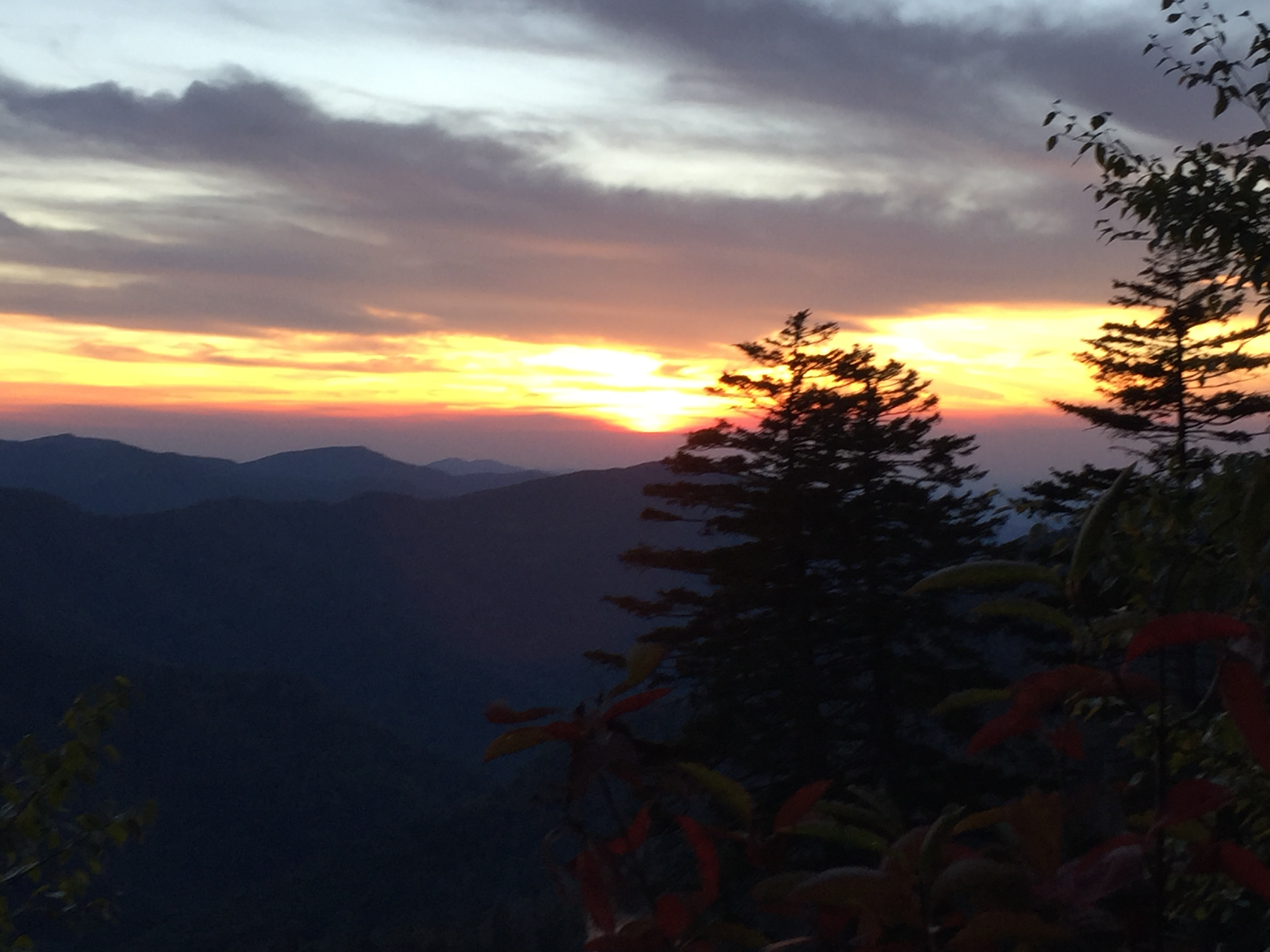
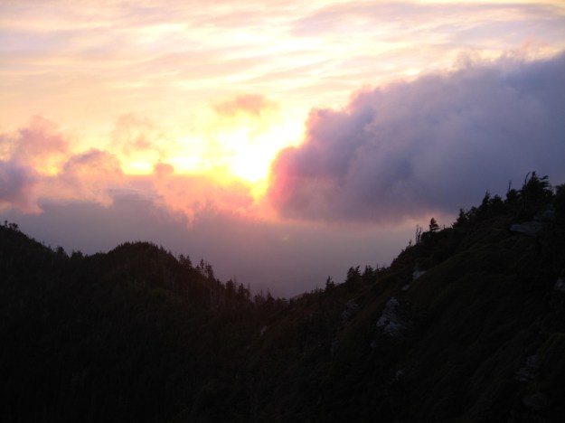
Sunset On Mt. LeConte

He was pacing back and forth on a small section of the North Kaibab Trail, 200 yards or so north of Phantom Ranch at the bottom of the Grand Canyon.  As I drew nearer, he was talking out loud, gesturing occasionally to no one around him.  The conversation concluded and as I passed him, he held up the smartphone and hit the “end call” button.  He turned his attention to me saying, “Can you believe it?  This is the only spot in the canyon where you can get a signal.”

As with any beautiful vista, one often shares the experience with others in quiet reverence as the moment is contemplated by each person’s reason for being there.  Such is the case at Cliff Tops on Mt LeConte at sunset.  There seems to be a profound respect shared by all who find themselves in the space and time of that moment.  It is a reward for the effort of hiking several miles and a few thousand feet in elevation.  However, there seemed to be a difference of opinion between two acquaintances in that the the one had no business saying what she said about the other; as the conversation was inadvertently shared with those around her during the moment the sky was on fire.  Apparently, there is a good signal up on Mt. LeConte.

“Why did you come here?”

The only electronics I took on my AT thru hike in 1984 was a flashlight, a digital watch and a small 35 mm camera, which had to be supplied with film. I replaced the batteries in the flashlight twice.  Navigation was accomplished by maps, a data book and the Philosopher’s Guide – all paper.  And the trip was documented in a small spiral bound notebook with a ball point pen.  The social network of the day was trail shelter registers, which were notebooks left by hikers providing news about trail conditions, AYCE restaurants in the next town, and who was hooking up with with whom.

The  presence of technology in the backcountry has changed the experience across the spectrum and like any powerful capability, one must come to terms with when to use it and when not to. Despite the tone projected thus far, please know that I am not a Luddite. I embrace technology, researching and carefully choosing which devices offer value to me and which require more support than the benefits they return.   The nature of this blog necessitates GPS technology to capture mileage, elevation and location.  My growing love affair with photography has opened up a completely new realm of technology possibilities.

My latest backpacking adventure underscored just how dependent I have become on my gadgetry.  Having  run out of battery charge on my GPS watch AND my smartphone, the last leg of my hike was not documented anywhere but in my mind.  No pictures, no voice recorder, no data.  I hiked the complete 7 mile length of the Pretty Hollow Gap trail in about two hours.  The next day, when I attempted to recount the section for posterity, I found I had little or no memory of the specifics of that hike.  For a blog that relies on information and data, this is bad.  The GPS, camera, and my voice reorder do in fact, help me remember details about each hike, solidifying the memory of them in my mind.  I remember where the water is in most campsites and I remember where all the big trees are.  I remember how many wet fords there are on each trail.  This is all good.

But I also came to realize that the hike down Pretty Hollow Gap put me in a state of contemplative flow, an experience which I have come to long for in the wilderness.  Without the constant awareness of checking the watch and recording where the switchbacks and stream crossings are, I was able to forget about time.  I remember being aware of the morning, the bird songs, the coolness of the air.  I don’t remember how steep the trail was and I don’t remember any stream crossings, although there has to be some.  There was regret in not having the information to document my hike, but upon reflection, what seemed to matter more was the memory of the contentment of that morning’s experience.  I reminded myself of the question –

“Why did you come here?”

HikerHead 2

Strider Out!


LeConte24 Part 4: Epilogue

“Anish Breaks the Appalachian Trail Unsupported Speed Record!” was the headline on the blog post: http://appalachiantrials.com/anish-breaks-the-appalachian-trail-unsupported-speed-record/

Anish is a woman some call “The Ghost” because she frequently hikes at night. Here’s the thing: Anish hiked the entire Appalachian Trail in 54 days. She hiked the PCT in 60 days. That means she averaged 42 miles a day and 44 miles a day respectively. And, she did both “unsupported” meaning there were no hot meals waiting for her in camp and probably zero “zero days”. Not only does she “frequently” hike at night, she most likely hikes every night.

View from Alum Cave Trail

View from Alum Cave Trail

Here is the text Brian sent me: “This lady just did our hike… 54 days in a row!”.

This is the backdrop as I am writing this summary of our own epic hike.  Three days ago, a young woman completed 54 days of hiking that we barely survived through one day.

All this said, I can say most humbly:

WE DID IT!!!!!!!!!

I set this blog up to keep track of individual trails I have hiked and will hike on this 900 Miler.  A hike like LeConte24 gets a little tricky to document because there are approach trails that don’t count as official miles and there are several miles that overlap like repeating a section of Trillium Gap to reach Brushy Mtn..  In short, Brian and I hiked a total 46.4 miles in 19 hours and 32 minutes, averaging 2.4 miles per hour.  Here are the data:

  • Total Miles:                             46.4 miles
  • Official miles:                         39.4 miles
    1. Rainbow Falls    6.6
    2. Trillium Gap       8.9
    3. Bull Head           5.9
    4. Alum Cave         5.0
    5. AT                        2.7  (Newfound Gap to Boulevard)
    6. Boulevard          5.4
    7. Brushy Mtn.      4.9
  • Total Time:                              19:32
  • Average Pace:                         2.4 mph
  • Total Elevation Gain:             11,924 ft.
  • Temperature Range:             60 – 82 degrees
Bull Head Trail

Bull Head Trail

Brian kept much better records than me and his post on www.leconte24.com  has a lot of excellent detail.  Having done this hike 4 years ago, we have some comparisons to make.  The first hike was completed in 22 hours. Our justification for the original route was to hike down the longest climbs.  An hour and a half was spent in shuttling from Alum Cave to Greenbriar; a technicality we fixed this time by changing the route.  We also took much shorter breaks between segments; typically  30 minutes or less.  In fact, our shuttle from Alum Cave to Newfound Gap was only 30 minutes complete.

Another subtle difference is that this year, we went ahead and did the Brushy Mtn. summit, which is a 0.4 mile spur trail from the junction for Trillium Gap and Brushy Mtn.  We passed it the first time because it was not technically an approach trail up Mt. Leconte.  The ramification for me was that four years later I had to go back and hike it to complete my 900 miler; a twist that required an 18 mile hike to snag 0.4 miles.  Brian agreed to go ahead and grab this section with me.  The 0.8 mile roundtrip took about 22 minutes so if we adjust for that, the “official” LeConte24 – 2015 hike was 45.6 miles in 19:10, 2 hours and 50 minutes faster than 2011.

View from the summit of Brushy Mtn.

View from the summit of Brushy Mtn.

Final Observations

The route we took this year seems optimal:

  1. Up Rainbow Fall – Down Trillium Gap
  2. Up Bull Head – Down Alum Cave
  3. Shuttle to Newfound Gap
  4. Up AT to Boulevard – Down Trillium Gap/ Brushy Mtn.

It was the shortest possible shuttle time and it minimized the total elevation gain.  We did not seem to suffer from taking shorter breaks.  Usually we would stop at the top for 15 – 20 minutes to eat something.  At the bottom, we would eat our “lunches” which for me included peanut butter sandwiches, fruit and chocolate.  This strategy worked perfectly until the final segment.  We reached the top on the Boulevard Trail around midnight and we elected to continue on down Trillium Gap with no break and no food.  By that time, neither of us was very hungry.  In fact we both had bouts of nausea and stomach aches.  This proved fateful because we both hit the proverbial wall.  The last five miles were rather excruciating because we were both completely out of energy and the Advil no longer took the edge off our weary legs and feet.  We would have been much better off to force down some nutrition.  It will was pretty dumb because we were both carrying plenty of food in our packs.  I guess with the finish line in sight coupled with upset stomachs, we both decided to grind through it.  Despite all this, we still averaged 2.4 miles per hour at the end.

Shawn on the Rainbow Falls Trail

Shawn on the Rainbow Falls Trail

This hike is doable!  Brian and I are both above average in fitness level but we are not ultra marathoners (although Brian has recently completed a half Triathlon).  The key is steady hydration and plenty of calories throughout the hike.  We both carried hydration bladder packs which made it possible to drink constantly.  I estimate I consumed about 5 liters of water in addition to 24 oz of Gatorade at each meal.  Brian kept a great record of his calorie intake on leconte24.com.  If I were to guess, we should have each consumed about 600 more calories on the last segment.

I hike mostly solo but I have to say there was a profound benefit to hiking with a partner on this hike.  Having great company goes without saying.  Especially in the last segment, it was good to have someone to help with pace but more importantly, when you are physically and mentally drained and your vision is drastically curtailed, you stumble a lot (more than usual) and although neither of us had any dangerous moments, the potential to injure yourself in the middle of the night, miles from help is ever present.

It took us three vehicles to do this.  We left one at Greenbriar where we finished up and drove one to Rainbow Falls Trailhead where we started.  We arranged for Brian’s wife Tina to meet us at Alum Cave and shuttle us to Newfound Gap.

My Garmin fenix 2

My Garmin fenix 2

This was the first time I have used GPS based electronics.  Garmin and others now have pretty powerful GPS systems in a watch configuration.  The mapping functions are not as useful during the hike itself as the typical hiking data.  I always knew how many miles we were into the segment and the elevation at any given time.  This allowed us to manage our pace so we would not blow it all out early in the hike.  Both our watches drained completely of battery power before the end of the hike.  There are ways to better manage power usage.  The data from the watch can be uploaded to a web app and all kinds of data and graphs are available for analysis.

Mt. LeConte, at 6,593 ft., is the third highest peak in the Smokies and the 6th highest east of the Mississippi. It is the crown jewel of the Great Smoky Mountain National Park and a prize one has to earn.  There are no roads or shuttles or ski lifts.  Only feet and horseback.  The trails are all well maintained and clearly marked with signs.  The ridge is lined with spruces and Douglas Firs giving the smell of Christmas all year long.  It is certainly worthy of an epic hike.

Thanks to my great friend and brother Brian Thomas who shared this time with me…twice!

IMG_9277

Mt Leconte from Clingmans Dome

Mt. LeConte seen from Clingmans Dome

LeConte24 Part 3: Inside my head…

Boulevard Trail

Miles:   8.8       Elevation:   3724 ↑       Grade: 8%          

Hiking Time: 3:15       Pace:  2.8 mph       Avg. Temp.:   60

Map Miles Completed:   8.8       Total Map Miles:  36.5       Total Miles Hiked:   36.5

Newfound Gap at the beginning of the end

Newfound Gap at the beginning of the end

9:00 is a better start time than midnight.  man i’m freezing.  it’s not that cold but i’m shivering.  pull out the fleece.  it’ll come off in 15 minutes but right now, i’m freezing.  let’s get this picture over with and get moving.  watch that guy in the broken down pickup truck.  looks a little suspicious.  oh, good, he’s leaving.  so glad that truck cranked.

“Brian, you ready to go?  I’d need to hit the head right quick.”

“Yep. I’m ready to warm up so let’s move.”

it’s amazing but I don’t feel that bad after hiking almost 30 miles.  advil helped a lot.  i should have eaten more dinner.  it’s all good cause i have plenty of trail food.

Shawn: “Make sure to thank Tina for me.  She really helped us out by shuttling us up here.”

Brian: “You bet.  I think we made the right decision on the routing.  It took a total of 30 minutes to transport, eat and load up for the next segment.  Last time it took 1:45 to go around to Greenbriar.”

“We’re going to break 5:30 am all to pieces.  Heck, we’re going to break 4:00.  Do you think we can hit 3:30?  That would take 3 hours off our time.”

“I feel pretty good right now.  I think it’s a good chance we can. look, there’s the AT blaze.”

“It’ll take you all the way to Maine…”

“wow, pretty quick time to the Boulevard Trail.  that was a fast 3 miles.  crazy that the Jump Off is not on the official map.  even more crazy that trails like the horse trail around Smokemont are. a mile of mud and horse poop.  it’s just as well, there wouldn’t be much to see tonight.”

“We’re going down now.  A lot!  I’ve already climbed this elevation! I don;t want to do it again.  Do you know how much we descend?”

“I think it’s about 1,000 overall.  We head down until about 6 miles in.  Then we have to climb back up to the ridge.”

gotta be really careful.  legs are tired.  every time i stumble, i head for the edge of the trail.  Trees and rocks.  my head.  broken ankle.  can’t see much.  nice and cool though.  the night is clear.  thought there’d  be more stars than this.

“There’s a sign.”

I think it’s for Myrtle Point.  Yep that’s it…”

High Point is just ahead.  I wonder if I can get a picture of it…”

there’s the shelter, those guys we met at the Alum Cave trail said they were staying there.  It’s midnight.  we should wake them up and ask how far it is to Rainbow Falls. we should probably be quiet…

Rock Pile at High Point at midnight

Rock Pile at High Point at midnight

Trillium Gap/Brushy Mtn. Trail

Miles:   9.1       Elevation:   4,564↓       Grade: 9.5%          

Hiking Time: 3:50       Pace:  2.4 mph       Avg. Temp.:   60

Map Miles Completed:   5.4       Total Map Miles:  41.9       Total Miles Hiked:   45.6

9.61 miles.  i wish we could have figured out how to skip the Trillium Gap trail and just do the Brushy Mtn. trail. we’ve already done it anyway.  i don’t know why we’re counting Brushy Mtn. anyway.  technically, it doesn’t go all the way to the top.

“Hey Brian, did Dave Worth hike all 6 trails?”

“Yep.”

dang it!  i guess we gotta do it.  it’s not like we can hitch around it now at 1:00 in the morning.  9.78 miles.  man, we’re going slow.  i’m not sure having this GPS watch is such a great thing.  i keep looking down and we’ve only covered a tenth of a mile.  maybe it’s better not to know.  that way you’re surprised when you’re done.  we finished Alum Cave sooner than i thought.  9.81 miles.  that’s the fourth time the “low battery” warning came up.  i don’t remember the rocks being so big the last time.  how can they make the llamas walk on this stuff?  9.83 miles.  CRAP! we’re going slow.  my legs hurt. my butt hurts.  EVERYTHING hurts.  these big step things they put in the trail don’t help a bit.  9.98 miles.  GREAT!

“10 miles in Brian.  We’ve descended about 1,200 feet”

Low battery again.  

“Hey Brian, my watch isn’t going to last much longer”

“Mine’s dead too.  Hopefully it saved the data.  Be a shame to lose the whole day.”

great!  spend $300 on a fancy watch that can tell you how many steps you take and it can’t last a whole day.  

Brushy Mtn. Trail Junction

Brushy Mtn. Trail Junction

FINALLY!  Brushy Mt. trail.  i love seeing those signs. 4.5 miles to Porters Creek.  i can make this. i hope we’re done with the rocks.  Brushy Mtn. trail is one of those old logging road beds right?  i don’t remember. 

Brian: “We did the right thing hiking the spur trail to the summit this afternoon.  I’m so glad we don’t have to do it in the dark.

Me: “It, would have been pointless.  We wouldn’t see much except the city lights would be cool”

the rocks are still here and now there’s overgrowth. at least there hasn’t been any blow downs to climb over. WAIT! don’t say that, we still have 4 miles to go.  don’t kill the mojo!  i thought the cicada’s or whatever these things are would be gone by now.  i guess it’s better than dead quiet.  i thought we would hear an owl or something.  at least there’s no motorcycles in the distance.  no bears today.  wonder what happens if we hear that loud huffing sound. 12.6 miles.

“Hey Brian, 4 miles to go and we’ve descended about 2,200 feet.”

“It’s 4 miles to Porter’s Creek.  We still have the gravel road.  It’s another mile.”

“Are you sure??!!!

“I’m sure”

CRAPPPPP!!!! now i’m playing mind games on myself.  5 miles to go and it hurts every step.

“Brian, how are you feeling?”

“OK”

he’s lying.  my whole body hurts.  we’re both slowing down.  i felt so good at Newfound Gap, even going uphill.  should have eaten something but my stomach hurts.  drink some water.  10.13 miles. “low battery” AGAIN!  i gotta sit down a second.  i’ll let Brian hike on ahead and i’ll catch up.  i could fall asleep right now.  just a little nap.  it wouldn’t hurt our time that much.  WHAT AM I SAYING???!!!!  get up slacker.  OOOOOO my legs hurt.  great, Brian waited on me.  

“Hey Brian.  I’m dead!

“You mean you or your watch?”

“Both”

now what am i going to do?  i can’t tell our progress.  that’s it.  it’s way better to know and keep looking.  now all i can do is suffer.  got nothing left to talk about.  can’t see anything.  those cricket things won’t shut up!  my headlamp is a lot brighter than Brian’s.  i should lead for a while but i need him to pace me now.  i could count steps.  no, that’s just stupid.  i could pull out my phone and check the time but then i’d have to hold it.  i could ask Brian to check the time, he’s got that belt pocket.  nah, just grind it out.  working through the pain sounded honorable at high school football practice but it just sounds stupid now.  at least the trail’s finally smoothed out.  it’s really flat here. we gotta be close to the road. there’s a switchback.  switchbacks are good.  change of direction. something’s different.

Brian: “It’s the gravel road”

Me:  “Finally. Do you think we can pick up the pace?

Brian: “I don’t have much left.”

Me: “Me either.  We’re almost there.”

i REALLY hope we were supposed to turn left.  Brian seems sure.  i should ask.  no i trust him.  i REALLY hope he’s right. maybe he’s almost delirious like me.  are you crazy if you know you’re going crazy?  wait, that’s a catch 22.  i can’t be crazy because i’m thinking about being crazy. i wonder where the other end of this goes.  what would we do if we turned the wrong way?  nah, Brian knows.  i should ask. no i trust him.  I REALLY hope he’s right.  we’re moving faster.  that’s good.  chocolate milk is waiting in the truck.  cold chocolate milk.  i REALLY love chocolate milk.

“There’s some sort of light ahead!  Was there a street light at the trail head?”

“Don’t think so.”

LeConte24 - 2015: THE END!

LeConte24 – 2015: THE END!

“Wait, it’s the reflectors on the gate.  WE”RE DONE!!!”

“4:05 am.  We cut an hour and a half off our planned time, which was two hours off our first time.  19 1/2 hours.  Plus we added the Brushy Mtn. summit. WE DID IT!!!!”

LeConte24 Part 2: Bull Head to Alum Cave

Bull Head Trail to Alum Cave Trail

Miles:   6.8       Elevation Gain:   3687↑       Grade:  12%          

Hiking Time: 2:47       Pace:  2.4 mph       Avg. Temp.:   80 – 64

Map Miles Completed:   6.8       Total Map Miles:   22.2       Total Miles Hiked:   22.2

Brian at the Bull Head Trailhead

Brian at the Bull Head Trailhead

At this point “Bull Head” is aptly named.  By now we have had a few interactions with other hikers, exchanging the typical pleasantries like:

“How far is the falls?”

“Oh, ’bout a mile, mile and a half.”  (Everyone knows this is the standard answer , even if it’s really 900 yards)

“Where ya’ll from?”

“Knoxville and Sevierville.”

“Ya’ll stayin’ up on LeConte tonight?”

Now the answer to that question get’s tricky.  We could say “no” and move on.  But if we say “sort of”, then we have to explain that we will, in fact, be spending the night somewhere up on the mountain, but we won’t be sleeping.  Choosing which answer depends on several factors.  First, are we due for a break?  If so then we go with “sort of.”  If the inquisitor is wearing street shoes, we quickly reply with “no” and tell them the trailhead is about a mile, mile and a half.  On the other hand, if their pack looks cool and they’re not wearing bear spray on their hip belt, we usually engage.

Reactions are always mixed.  Some think we’re crazy while others are duly impressed. Once the conversation starts, we know we are headed for the question.  “To see if we can do it,” is the answer Brian and I have agreed on.  Now back to the aptly named Bull Head Trail.  I imagine most folks walk away with some analogous notion of the two of us being bullheaded.

Early Signs of Fall on Bull Head

Early Signs of Fall on Bull Head

The Smokies benefit from having four distinct seasons and each is beautiful.  Winter brings the wonderland of snow and frozen waterfalls.  Spring and early summer bring laurel, rhododendron and the incredible wild dogwoods.  Summer is green and lush, and the Fall….  we are on the verge of a wildfire of color and some of the trees have gotten an early start.  Bright crimson red and against a backdrop of lush green, all under a deep blue sky.  Only one Artist is capable of this quality of painting.

Bull Head is a steady climb and not very rugged compared to Trillium Gap.  Much of it was in the afternoon sun.  About 2 miles in, a trio of college guys passed us and seemed excited to tell us about the bees up ahead.  They gave us a pretty clear description of the trail with a stump on the left and the trail turning into direct sunlight.  We asked them about how far ahead it was and they said, “about a mile, mile and a half.” (Who did they think we were, street shoe people?)  Turns out they were right.  For some reason, Brian insisted that I take the lead on this section.  It was only fair because four years ago, on this very same trail, our quartet ran into a yellow jacket nest in a water bar log.  Everyone got stung but me.  We turned on a bend and saw trail that matched the description.  We walked carefully looking for tiny flying beasts.  It’s amazing how many flying insects you see when you’re looking for bees…  We made it past the stump and I thought we were clear and then BANG!  A yellow jacket hit me about six inches above my left heel.  Could have been worse i guess.  Brian, my buddy… my hiking comrade, my brother in arms simply said, “Well, now we’re even.”  (How did he know???!!!!!!)

From this point on, we were obligated to tell anyone we met about the hazard.  It became a bit.  We would say hello and Brian would look at me and say:

“Should we tell them about the bees?”

“Nah, they’ll find ’em”

Of course we would pass on the description and wish them well.

The sun was headed down by the time we got to the Alum Cave Trail junction.  We stopped for water and a few granola bars.  We left the trail head with 80 degree temperature but it was 64 by the time we got to the top of the ridge.

Halfway Point!


Alum Cave Trail

Miles:   5.5       Elevation:   2419 ↓       Grade: 9%          

Hiking Time: 1:56       Pace:  2.8 mph       Avg. Temp.:   66

Map Miles Completed:   5.5       Total Map Miles:  27.7       Total Miles Hiked:   27.7

Shawn making sure of the right path on Alum Cave

Shawn making sure of the right path on Alum Cave

The first LeConte24 hike ended up descending on the Alum Cave trail.  We caught a beautiful sunset and this segment would prove no different.  Having already hiked to the summit on the Rainbow Falls Trail,  we opted to take a quick right on Alum Cave.  This year, the great folks in the Park Service and the Smoky Mountain Hiking Club are renovating the Alum Cave Trail to improve erosion control, shore up some of the rockslide areas and generally beef up the trail to handle all the traffic.  This construction necessitates its closing on Monday through Thursday through November 2015.  Fortunately for us, it was Saturday, at least for a few more hours.  The main thing was the fact that darkness would catch us before we reached the trailhead but we were prepared with headlamps.  A lot of hiking equipment has gotten cheaper over the years but not so with headlamps.  My brand-new Black Diamond has a 200 lumen bright beam, a wide angle flood light and if you hold the button down just right, the red lights will turn on.  All for a cool $50 bucks.

One of the cliff-side sections of Alum Cave

One of the cliff-side sections of Alum Cave

The improvements on Alum Cave became apparent as we got down the trail a bit.  Sections were wider and there are a number of step constructions that smoothened out some of the more treacherous parts.  There are still those sections on the edge of cliff one should take care to cross, especially in the fading sunlight.  Fortunately, the trail was dry and safe.

The sun was really fading fast and yielded some incredible views while we were still on the upper section.  We wanted to stop and contemplate the moment but the clock was ticking on so we snapped a few pictures and kept moving.

Alum Cave is popular for several reasons.  It is the shortest route to the top of Mt. LeConte and the parking area is large and easily accessible.  While steep, it is not as rugged as some of the other routes.  It has some unique features like the cliffs, Arch Rock and the famous bluffs.  After the renovations are complete it will be one of the best hiking trails in the park.

Sunset on Alum Cave Trail

Sunset on Alum Cave Trail

IMG_1429

Alum Cave Bluff at dusk

Shawn approaching Arch Rock carefully in the dark

Shawn approaching Arch Rock carefully in the dark

LeConte24 Part 1: And So It Began…

Rainbow Falls to Mt. LeConte

Miles:   6.7       Elevation:   3601↑       Grade:  10%       Avg. Temp.:   64

Map Miles Completed:   6.7       Total Map Miles:   6.7       Total Miles Hiked:   6.7

It was a dark and stormy night…  No it wasn’t.  It was a clear, cool, beautiful morning.  The kind that suggests what the 6th day of creation must have been like.  Except for the cars in the parking lot…

Brian and Shawn at the Rainbow Falls Trailhead

Brian and Shawn at the Rainbow Falls Trailhead

LeConte24 – 2015 got underway about 8:30 am on Saturday, September 19.  According to my hiking buddy and good friend Brian Thomas, it was this same weekend 4 years ago when we did this the first time.  We decided to hike all 6 trails on Mt. Leconte on a whim after we heard about Dave Worth’s record break
ing hike a few weeks earlier.  We had no expectations of breaking records; only completing the hike in 24 hours.  It became the impetus for completing my first 900 miler.

A complete account of it, plus Brian’s excellent post of this hike can be found on our blog: www.leconte24.com.  The goal this time was to cut a couple hours off our time of 22 hours.  Brian redesigned our route to minimize shuttles between trailheads and optimize elevation gain in our favor.

The new route: Up Rainbow Falls, down Trillium Gap; up Bull Head, down Alum Cave; shuttle to Newfound Gap; up Boulevard, down Trillium Gap/Brushy Mtn.

IMG_1348This time, rather than starting at midnight, we chose to begin in the morning after a good night’s sleep.  We dropped my vehicle off in Greenbriar where we planned to end the hike around 5:30 the next morning.

The hike to Rainbow Falls was pleasant.  We targeted a 2.5 mph pace but actually had a hard time keeping it under 3.  The time was spent catching up on our lives and greeting other hikers we passed.  Rainbow Falls flowed barely more than a trickle here in mid-September.  We stopped for a quick pic and moved on. We got to the top in about 2:44, 2.45 miles per hour which was right on target.  Time for some food and water then on to Trillium Gap.


Mt. LeConte to Trillium Gap

Miles:   9.6       Elevation:   3654↓       Grade:  8%       Avg. Temp.:   64

Map Miles Completed:   8.5       Total Map Miles:   15.2       Total Miles Hiked:   15.6

IMG_1390Finding the Trillium Gap trail at the top of LeConte can be a challenge because it’s kind of hidden in tall plant growth off to the side of the cabins.  Brian went right to it though and we were off.  Trillium Gap is pretty rocky most of the way.  It’s also the route the llamas take when they resupply the lodge.  The Park Service installed several step sections to control erosion but they are not a smoother alternative to trail.  This will become challenging later in the hike but with fresh legs, we descended steadily to the junction with Brushy Mtn.  Here we had a decision to make.

The last time we did this, we passed on the spur trail to the summit of Brushy Mtn.  It was not on the agenda for hiking the trails up LeConte.  However, it IS on the official park map so that means a 900 miler has to hike it.  This decision caused me to have to do an 18 mile hike later in order to complete the 0.4 mile section to the summit of Brushy Mtn.  Although it was an additional 0.8 miles, Brian was gracious to head off on the spur trail with me.

View from the Summit of Brushy Mtn.

View from the Summit of Brushy Mtn.

The effort was rewarded with some of the most incredible views we would have that day.  Brushy Mtn. is a bald, although the prodigious plant growth is worthy of the mountain’s name.  The only other time I was in this place, it was socked in and there were no views whatsoever.  The trail just ends at the top, kind of like a cul-de-sac.  We were up and down within 20 minutes and ready to continue down Trillium Gap.

A crowd of civilians enjoying Grotto Falls

A crowd of civilians enjoying Grotto Falls

Grotto Falls was a popular spot with dozens of people playing in the water and taking pictures.  A line formed on the trail at the edge of the waterfall as people wanted their picture taken behind it.  It’s good to see kids hiking and enjoying the park.  Nervous parents try to make sure the children don’t slip on the rocks.

Eventually we got to the parking area and the trail turned to follow the road back to the Rainbow Falls trailhead.  We debated whether or not this section of trail was official Trillium Gap Trail or just a connector.  My mind went back to thinking about how we could have bypassed it but that was wishful thinking.  At the trail head, the official milage included that section.  Oh, well.  At least the effort wasn’t lost.  The  8.9 mile descent took 3:15 including the spur trail to Brushy Mtn. at an average of 2.7 mph.  Right on schedule!  Time for lunch!

Prelude

Every journey has a beginning and an ending.  Given that humans are creatures bound by time and space, we tend to measure our journeys with various milestones and devices including clocks and maps and events.  All this effort serves to provide the stuff we use to tell the stories of our adventures.

The AT Thru-hiker starts somewhere, usually Springer Mtn., GA and ends, usually on Mt. Katahdin, ME.  Thru hikers will count the days and in some cases the hours.  They may track dates and locations and miles covered.  Rituals mark the start and finish such as signing in at the ranger stations in Amicalola State Park and at Baxter State Park.  Packs are weighed.  Pictures are taken.  Good-byes are said.  Tears are shed.  Memories are forged.

I suspect with 900 Milers, many don’t mark the beginning of their 900 miler journeys; at least the first time.  With me it was an awareness of having hiked several trails and then reaching the point where I decided to start tracking the mileage and the dates of which trails were hiked.  As a consequence, the actual “beginning” of the journey is not marked by any ritual or celebration.

But the second map is different.  A second 900 Miler is deliberate.  One begins with an awareness of what is to come and the challenges ahead.  Such an undertaking should be marked with a worthy kickoff.  Some sort of event that is befitting a four-year project such as starting on an iconic mountain.  Perhaps a unique challenge that is difficult and memorable.  Perhaps it is an activity for which the answer to the question “Why?” is difficult for the casual observer. Perhaps the answer to that question is simply, “because I wanted to see if I could…”

Mt. LeConte – Sunset from the Lodge

So why not hike all the trails up Mt. Leconte?  In 24 hours?  It’s a 45.7 mile challenge and it’s doable.  I know this because I did it 4 years ago.  That hike was documented in detail at www.leconte24.com.  My original hiking partner for that hike was Brian Thomas and he is joining me again for this chapter. From what we learned the first time, Brian designed a route that minimizes altitude climbing and shuttling between trailheads.  With this new route, we hope to cut 2 hours off our original time of 22 hours and it will save about 900 feet of climbing.

Here is the new itinerary:

  1. Park at Rainbow Falls/ Bull Head Trail head
  2. Up Rainbow Falls (4,000 ft.) – Down Trillium Gap
  3. Up Bull Head (4,000 ft.) – Down Alum Cave
  4. Shuttle to Newfound Gap
  5. Up Boulevard (3,724 ft.) – Down Brushy Mtn.
  6. Car at Brushy Mtn. Trailhead in Greenbriar.

Date and time:  Saturday, September 19, 2015, 9:00 am EDT.

And so it begins…