Date: May 21 – 22, 2018
Miles: 21.1
Having completed the first loop of my backpacking trip, I enjoyed some lunch while catching glimpses of elk at the edge of the trees in Cataloochee Valley. Plus, I had to dry out my shoes, not to mention my feet pickled by the miry swamp that was the Caldwell Fork Trail. For this loop, there were three entry points depending on how much hiking I wanted to do the second half of the day. I did a quick check of the mileage if I stayed in Cataloochee and started up Pretty Hollow Gap, taking Little Cataloochee Trail to Long Bunk and then up Mt Sterling Trail. With about 7 miles done in the morning, I figured another 10 or so would get me to the top of Mt. Sterling and CS# 38. Not only did I miscalculate the mileage by about 4 miles short, I also failed to realize the magnitude of the 13.7 mile climb that was in store for me that afternoon. Pretty Hollow Gap leaves Cataloochee Road at 2,717 feet and the day ended at the top of Mt. Sterling at 5,840. Overall, it was a 21.4 mile day and a 3,823 ft. climb ending in a 12% grade up Mt. Sterling Trail.
But enough whining.
With after a lunch of summer sausage, Tillamook cheddar, pistachio nuts and a few granola bars, I started out on Pretty Hollow Gap Trail refreshed and dry of feet at about 12:45. The trail is a gravel road for a quarter mile or so, passing the Cataloochee horse camp at 0.2 miles. I took the right onto Little Cataloochee Trail and started a easy climb up toward NC 284. There are a few rock-hopper stream crossings in the first mile and a half making for damp feet but the climb is moderate until you reach a switchback and a ridge crest a tenth of a mile ahead, where there is a nice clearing for a rest. At about 2 miles, the trail bends at a rock fence typical of this area. Not too far beyond the bend, the  trail arrives at the Dan Cook Cabin at 2.5 miles, which is a delightful setting with notched joints and a split rail fenced yard. Across the trail from the cabin is a ruin of a rock walled building the guidebook called an apple house. The trail becomes a gravel road past the cabin. I noticed on this section there was fire damage on the right side down in the hollow, yet the fire did not jump the road as the upper left side was
  pristine. The Little Cataloochee Baptist Church appears at 3.2 miles with its large cemetery. I did not spend time investigating either spot as I wanted to get the afternoon’s hiking done but I remember there being graves dating back to the civil war.
Continuing down the road, the fire damage picked back up just past the yard of the church. I noted that whatever the fire event was, it burned right up to the edge of the church property and stopped. Less than a mile past the church, a side trail leads to the  Hannah Cabin, which is unique for it’s brick chimney. Just 0.2 miles past Hannah Cabin is the Long Bunk Trail intersection. From there it’s a mile to NC 284. I took a brief water and granola bar break at the road. 900 Miler purists will note that I did hike the mile out and then back to Long Bunk Trail rather than call it even, but that ethical decision added two of the miles I failed to calculate in the afternoon mileage. This trailhead was the second choice for starting the loop and would have only required a 7.8 mile hike to Mt. Sterling. In retrospect, it would have been a better choice for this loop.
The steady climbing continued on Long Bunk Trail. It was 4:00 when that hike began and I was still over 6 miles from the end of the day. The Hannah Cemetery is at 0.2 miles and there were fresh flowers on a couple of the graves. Past the cemetery, the jeep track became a single track pathway. There are a few shallow streams to cross over the next mile but with deft stepping, the feet can remain dry. Long Bunk Trail is rather unremarkable in its features. It is a steady climb on good trail and it terminates on the Mt. Sterling Trail about a half mile in from the road. I completed the 3.7 miles in an hour and a half.
This time I dropped the pack to hike the half mile out to the road, which is the third option for starting the loop. Touching the gate, I immediately turned around started the watch to count the miles on Mt. Sterling Trail. Much of the trail is a primitive jeep track that serviced the fire tower on the summit. The pack was waiting for me at 0.5 miles and I donned it for the last 2.2 miles of the day. The switchback at 0.8 miles was a slap in the face because it began the more strenuous part of the trail that would continue to the top. The climb was steady, not severely steep or rugged but on top of 20 miles, it was miserable going. I didn’t make any voice recordings after the switchback at 1.6 miles but I remember going a tenth of a mile, catching my breath, then repeat. The mind plays tricks on you when you are exhausted and still have a long way to go. Actual mileage lengthens to fill the worst depths of your imagination. You begin to notice damp rocks in the trail and wonder if you could get enough water to make camp right in the trail. No energy in the legs and the heart only beats so fast at this point in the day. There is nothing to do but keep plugging with an eye toward dinner. The 2.7 miles took a pitiful hour and a half to get done and there was rejoicing when the trail broke the top of the ridge, leading 0.4 miles to the summit.
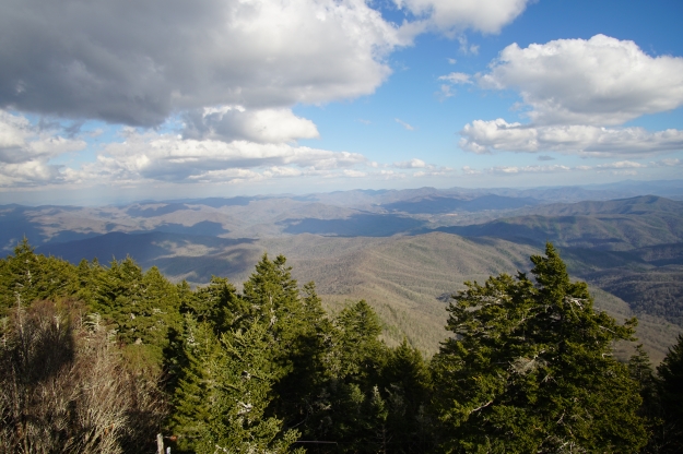
 The trail ends in a clearing that is the home of a fire tower standing watch over the far northeast end of the Park. The views are spectacular and I couldn’t wait to summon the energy to grab some pictures before sunset. But the first order of business was to get water for the night. I was out and also dehydrated. The water source is almost a half mile down the Baxter Creek Trail just past the fire tower and it IS steep. The side trail leads 700 yards to a small piped spring that, at best, offers a trickle of clean cool water. I dropped the pack, and stripped to my skivvies because everything was soaked and I figured it would be easier to dry off by moving around. With the water bag filled, I climbed back up to the campsite, grabbed my fleece jacket and camera and climbed the tower to the landing just below the top. Then I sat down.
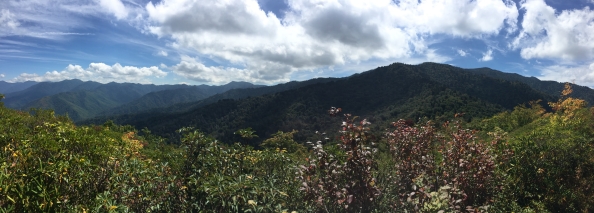
The sun hung low in the evening sky but still lit up the clouds brilliantly. I snapped a dozen or so shots with different f-stops and wide angles, hoping to get at least one good shot to capture the moment. The wind was picking up and I was still pretty damp with body moisture. Chills were setting in as the sun got low.

I decided dinner was the next challenge to accomplish but before that, I hung the hammock among the evergreens that adorn the top of this beautiful ridge. There was a bivy style tent in a spot nearby but there was no sign of another human being. Despite the small tent, there was no pack or food bag hung on the bear cables. I opted not to “knock on the door’ and introduce myself to the neighbor. I was thankful for the quiet loneliness. I had been looking forward to camping here for a long time and the peacefulness was a reward for the hard day’s work.
I got my stove ready for dinner, poured the cup of water to boil and opened the pouch to ready the ingredients. There were two pouches; one obviously food and the other was a “heating element.” Bewildered, I read the package to figure what exactly I had brought along for dinner. It was a self-heating backpacking dinner. Who knew? There is a white package of some material, which you cover with water in the meal package and you dump in the other pouch of food, unopened of course. The material spontaneously starts to “boil” the water, with steam and everything. After 10 minutes, diner was warm enough to eat and it was pretty good, although one must adjust for the quality of food, accounting for camping after 22 miles of hiking uphill. My shoes would probably have tasted pretty good at that point.
The setting sun was taking its light down with it and after a bit of clean up, I secured things for the night. Anticipating a cool wind, I unrolled my thermal pad but I decided to try it uninflated. The wind was picking up as I wiggled into my cocoon for the night. I warmed up quickly and started to doze as darkness settled. The wind rattled the fire tower and I heard the typical animal activity as I was drifting off. Within a few minutes there were voices., Having ruled out a dream and being reasonably sure the voices were outside my head, it turned out to be a few late arrivals. They must have been as exhausted as I was because after a couple tents were thrown up, they got quiet pretty quickly and we went back to the low roar of the wind to sing us to sleep.
Hammocks sleep cold. My experiment proved to be a failure as the wind blew under and around every surface in contact with my backside. While I wasn’t freezing, I was not warm either. I finally inflated the thermal pad and I was immediately toasty and warm. The final report: You gotta take some insulation with a hammock, even in the summertime. Once I was warm, I slept soundly for the second night in a row.
I awoke early and set up for breakfast. The owner of the bivy tent could still not be seen but I did meet one of my late arriving neighbors as I boiled water for my oatmeal and coffee. The three of them had come up Baxter Creek Trail, which must have been a killer that late at night. I offered the balance of my water so he wouldn’t have to negotiate the walk to the spring. Packing up a hammock goes quickly and I was on the trail a little after 7:30 am. Mt. Sterling Ridge Trail to Pretty Hollow Gap and out the trail named for the gap. My arduous effort the day before would reward me with a 7 and a half mile hike back to the trailhead.
The details of this part of the hike are pretty sketchy. I had brought a battery charging device for my watch but I failed to include the proper cable. Furthermore, my phone battery was all but dead as well. The features and fallacies of technology are a topic for another post, but here, let me say that it is amazing how much detail one forgets when not archiving it somehow. Mt. Sterling Ridge is a steady downhill hike from its start at the Mt. Sterling Trail, following the ridge as it descends into Pretty Hollow Gap where there is a crossroad of trails. To the right is Swallow Fork Trail, which leads down to Walnut Bottom, one of my favorite camping spots in the Park. My path took me to the left down Pretty Hollow Gap Trail, which looses about 2,000 feet along its 5.6 miles. In my anxiousness to finish, coupled with all my technology being dead, I remember very little of that hike except that I got to the bottom before 10:00.
The final tally was 38.9 miles in less than two full days of hiking. I can’t speak for high altitude but I think I am in reasonably good shape for the JMT in a month.


