
The permitting process allows for (requires?) a daily itinerary. Recalling my last post and the utter frustration one meets in trying to complete this process before a 5-minute timeout, only to find out the system accepts incorrect destinations once you are past your entry and exit point, I had to go back to fill it all in with the right stuff. So after careful research and planning out reasonable daily mileages I came to realize that most of the campsites are not available in the drop down menus of the permitting process so officially, I am spending most nights at a place called “other”. I really hope it’s nice and there’s water.
As Patton said, “No battle plan survives first contact with the enemy,” which calls into question why one would even try to plan out an itinerary. My AT thru hike itinerary many years ago was pretty much blown up the first day. But the value in planning is not the end product, but the process of thinking through various strategies. In this case, where to re-supply. There are a number of resupply points along the first half of the JMT, but there is only one for the last half and that is at Muir Trail Ranch. Since I am actually entering the trail officially at Rush Creek, I only need 5 days of supplies to get to Muir Trail Ranch so I guess it’s just one re-supply for me. Much more on that later. My itinerary calls for 10 days of supplies from there to Whitney Portal.
There are some excellent resources to help plan a thru hike of the JMT. Most promote a 21-day itinerary, which I loosely followed. Here is the list of references that were helpful in this project:
- The John Muir Trail: Through the Californian Sierra Nevada by Alan Castle
- John Muir Trail: The Essential guide to Hiking America’s Most Famous Trail by Elizabeth Wenk
- John Muir Trail Data Book by Elizabeth Wenk
- John Muir Trail Topographic Map Guide by National Geographic
I am hopeful of beating this schedule to some extent as I generally hike 15 – 18 miles a day but there are a couple caveats – First, the highest mountains on the east coast are only 6,000 feet, while much of the JMT is above 10,000 feet. I am brushing up on those who have had bouts with altitude sickness and the general word is that hiking south, you get to acclimatize to some extent. The second issue is the specific exit date, which is required of the permitting process. Who knows what happens if you try to leave early… Do the rangers make you go back and wait it out or do they just write out a ticket? Who knows? I imagine this will be a topic of conversation once I am on the trail. At the very least, maybe I can save up some time for a zero day somewhere really nice.
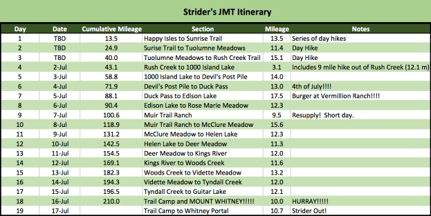
So here is it, the published itinerary:
That is all…
 Strider Out!
